
Last modified: 2024-01-20 by antónio martins
Keywords: (no keywords) |
Links: FOTW homepage |
search |
disclaimer and copyright |
write us |
mirrors
|
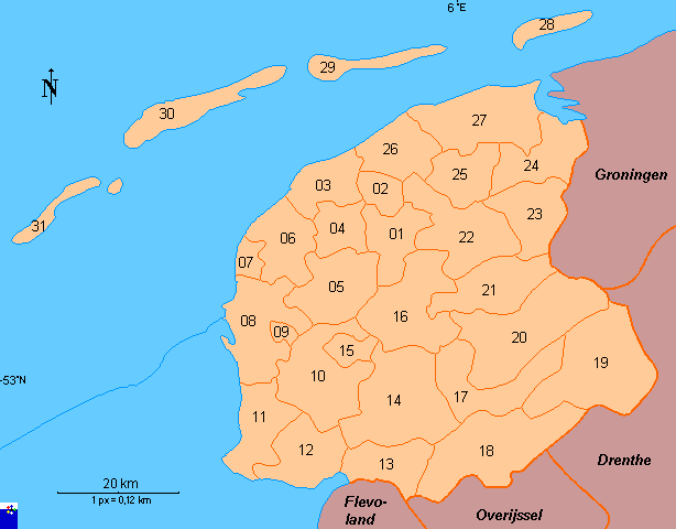
01 Leeuwarden / Ljouwert 02 Leeuwarderadeel 03 Het Bildt* 04 Franekeradeel* 05 Littenseradiel* 06 Menaldumadeel* 07 Harlingen 08 Wûnseradiel 09 Bolsward 10 Wymbritseradiel |
11 Nijefurd 12-14 De Fryske Marren 12 Gaasterlân-Sleat 13 Lemsterland 14 Skarsterlân 15 Snits 16 Boarnsterhim 17 Heerenveen 18 Weststellingwerf 19 Ooststellingwerf 20 Opsterland 21 Smallingerland |
22 Tytsjerksteradiel 23 Achtkarspelen 24 Kollumerland en Nieuwkruisland 25 Dantumadeel 26 Ferwerderadiel 27 Dongeradeel 28 Schiermonnikoog 29 Ameland 30 Terschelling Island 31 Vlieland |
Copyright: FOTW Friesland map by Franc van Diest and boundaries’ data by Jarig Bakker. If you wish to reuse them on your website, read our copyright rules.
Anything below this line was not added by the editor of this page.